EEweather: Weather station wrangling for EEmeter


EEweather — tools for matching to and fetching data from NCDC ISD, TMY3, or CZ2010 weather stations.
EEweather comes with a database of weather station metadata, ZCTA metadata, and GIS data that makes it easier to find the right weather station to use for a particular ZIP code or lat/long coordinate.
Supported Sources of Weather Data
- NCDC Integrated Surface Database (ISD)
- Global Summary of the Day (GSOD)
- NREL Typical Meteorological Year 3 (TMY3)
- California Energy Commission 1998-2009 Weather Normals (CZ2010)
Features
- Match by lat/long coordinates
- Convert ZIP code (ZCTA) to lat/long coordinates of its centroid
- Use user-supplied weather station mappings
- Match within climate zones
- IECC Climate Zones
- IECC Moisture Regimes
- Building America Climate Zones
- California Building Climate Zone Areas
- User-friendly SQLite database of metadata compiled from primary sources
- US Census Bureau (ZCTAs, county shapefiles)
- Building America climate zone county lists
- NOAA NCDC Integrated Surface Database Station History
- NREL TMY3 site
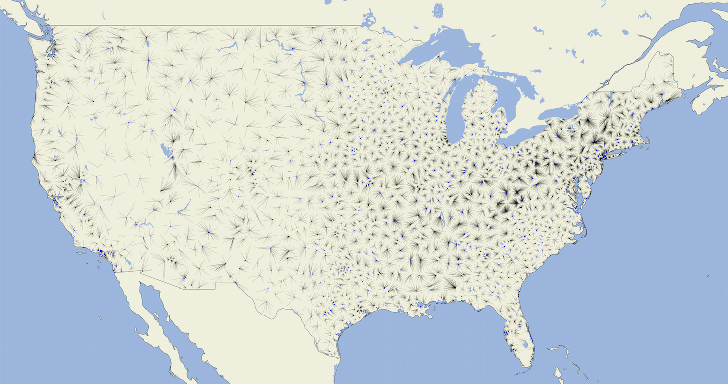
- Plot maps of outputs
Command-line Usage
Once installed, eeweather can be run from the command-line. To see all available commands, run eeweather --help.
View ISD station metadata:
$ eeweather inspect_isd_station 722874
{
  "usaf_id": "722874",
  "wban_ids": "93134",
  "recent_wban_id": "93134",
  "name": "DOWNTOWN L.A./USC CAMPUS",
  "latitude": "+34.024",
  "longitude": "-118.291",
  "elevation": "+0054.6",
  "quality": "high",
  "iecc_climate_zone": "3",
  "iecc_moisture_regime": "B",
  "ba_climate_zone": "Hot-Dry",
  "ca_climate_zone": "CA_08"
}
Download raw ISD files:
$ wget `eeweather inspect_isd_filenames 722874 2017`
Download raw GSOD files:
$ wget `eeweather inspect_gsod_filenames 722874 2017`
Enter the SQLite command line for the metadata database:
$ eeweather inspect_db
SQLite version 3.19.3 2017-06-27 16:48:08
Enter ".help" for usage hints.
sqlite> .tables
ba_climate_zone_metadata       isd_file_metadata
ca_climate_zone_metadata       isd_station_metadata
cz2010_station_metadata        tmy3_station_metadata
iecc_climate_zone_metadata     zcta_metadata
iecc_moisture_regime_metadata
sqlite> .headers on
sqlite> select * from isd_station_metadata where ca_climate_zone = 'CA_06' limit 10;
usaf_id|wban_ids|recent_wban_id|name|latitude|longitude|elevation|quality|iecc_climate_zone|iecc_moisture_regime|ba_climate_zone|ca_climate_zone
722883|99999|99999|HERMOSA BEACH PIER|+33.870|-118.400|+0008.0|low|3|B|Hot-Dry|CA_06
722885|93197,99999|93197|SANTA MONICA MUNI AIRPORT|+34.016|-118.451|+0053.0|high|3|B|Hot-Dry|CA_06
722913|99999|99999|MARINA DEL REY|+33.970|-118.430|+0008.0|low|3|B|Hot-Dry|CA_06
722917|99999|99999|LONG BEACH|+33.770|-118.170|+0003.0|low|3|B|Hot-Dry|CA_06
722933|99999|99999|SAN CLEMENTE|+33.420|-117.620|+0003.0|low|3|B|Hot-Dry|CA_06
722935|99999|99999|EL CAPITAN BEACH|+34.467|-120.033|+0027.0|low|3|C|Marine|CA_06
722950|23174|23174|LOS ANGELES INTERNATIONAL AIRPORT|+33.938|-118.389|+0029.6|high|3|B|Hot-Dry|CA_06
722954|99999|99999|ZUMA BEACH|+34.020|-118.820|+0006.0|low|3|B|Hot-Dry|CA_06
722955|03122,03174,99999|03174|ZAMPERINI FIELD AIRPORT|+33.803|-118.340|+0029.6|low|3|B|Hot-Dry|CA_06
722974|99999|99999|LONG BEACH|+33.767|-118.167|+0003.0|low|3|B|Hot-Dry|CA_06
sqlite> .quit
Usage Guides
Basic Usage
This document describes how to get started with eeweather.
Matching to weather stations
EEweather is designed to support the process of finding sources of data that correspond to particular sites. As there are many approaches to this process of matching, the EEweather package is designed to be flexible.
EEweather provides sensible default mappings from geographical markers to weather stations so that it can be used out of the box.
EEweather uses lat/long coordinates as targets for weather matching. This method is described below.
Latitude/Longitude Coordinates
The recommended way to find the weather station(s) that correspond to a particular site is to use the lat-long coordinates of that site.
Example usage:
>>> import eeweather
>>> ranked_stations = eeweather.rank_stations(35, -95)
>>> station, warnings = eeweather.select_station(ranked_stations)
>>> station
ISDStation('720627')
>>> ranked_stations.loc[station.usaf_id]
rank                                     1
distance_meters                    32692.7
latitude                            35.283
longitude                            -95.1
iecc_climate_zone                        3
iecc_moisture_regime                     A
ba_climate_zone                Mixed-Humid
ca_climate_zone                       None
rough_quality                          low
elevation                            183.2
state                                   OK
tmy3_class                            None
is_tmy3                              False
is_cz2010                            False
difference_elevation_meters           None
Name: 720627, dtype: object
>>> warnings
[]
That particular result has no associated warnings, but other mappings may have associated warnings, such as the mapping from this point which is in the middle of the Gulf of Mexico, 700km away from the nearest weather station and outside of the climate zone boundary:
>>> ranked_stations = eeweather.rank_stations(20, -95)
>>> station, warnings = eeweather.select_station(ranked_stations)
>>> warnings
['Distance from target to weather station is greater than 50km.', 'Distance from target to weather station is greater than 200km.']
ZIP Code Tabulation Areas (ZCTAs)
ZIP codes are often abused as rough geographic markers. They are not
particularly well set up be used as the basis of a GIS system - some ZIP codes
correspond to single buildings or post-offices, some cover thousands of square
miles of land. The US Census Bureau transforms census blocks into what they
call ZIP Code Tabulation Areas, and use these instead. There are roughly 10k
ZIP codes that are not used as ZCTAs, and ZCTAs do not correspond directly to
ZIP codes, but for matching to weather stations, which are much sparser than
ZIP codes, this rough mapping is usually sufficient. Often tens or hundreds of
ZCTAs will be matched to the same weather station. We provide a function
eeweather.zcta_to_lat_long which allows for a ZCTA to be converted into
a latitude and longitude (the centroid of the ZCTA) which can be used to match
to a weather station using the latitude/longitude method mentioned above.
Note
The default mapping concentrates on weather stations in US states (including AK, HI) and territories, including PR, GU, VI etc).
Example usage:
>>> lat, long = eeweather.zcta_to_lat_long('91104')
>>> lat, long
(34.1678418058534, -118.123485581459)
Obtaining temperature data
These matching results carry a reference to a weather station object. The weather station object has some associated metadata and - most importantly - has methods for obtaining weather data.
Let’s look at the station object from above:
>>> station = result.isd_station
>>> station
ISDStation('722178')
This ISDStation object carries information about that station and methods
for fetching corresponding weather data.
The .json() method gives a quick summary of associated metadata in a
format that can easily be serialized:
>>> import json
>>> print(json.dumps(station.json(), indent=2)
{
  "elevation": 137.5,
  "latitude": 35.021,
  "longitude": -94.621,
  "icao_code": "KRKR",
  "name": "ROBERT S KERR AIRPORT",
  "quality": "high",
  "wban_ids": [
    "53953",
    "99999"
  ],
  "recent_wban_id": "53953",
  "climate_zones": {
    "iecc_climate_zone": "3",
    "iecc_moisture_regime": "A",
    "ba_climate_zone": "Mixed-Humid",
    "ca_climate_zone": null
  }
}
Most of these are also stored as attributes on the object:
>>> station.usaf_id
'722178'
>>> station.latitude, station.longitude
(35.021, -94.621)
>>> station.coords
(35.021, -94.621)
>>> station.name
'ROBERT S KERR AIRPORT'
>>> station.iecc_climate_zone
'3'
>>> station.iecc_moisture_regime
'A'
In addition to these simple attributes there are a host of methods that can be used to fetch temperature data. The simplest are these, which return pandas.Series objects. The start and end date timezones must be explicilty set to UTC.
Note that this temperature data is given in degrees Celsius, not Fahrenheit. (\(T_F = T_C \cdot 1.8 + 32\)), and that the pd.Timestamp index is given in UTC.
ISD temperature data as an hourly time series:
>>> import datetime
>>> import pytz
>>> start_date = datetime.datetime(2016, 6, 1, tzinfo=pytz.UTC)
>>> end_date = datetime.datetime(2017, 9, 15, tzinfo=pytz.UTC)
>>> tempC = station.load_isd_hourly_temp_data(start_date, end_date)
>>> tempC.head()
2016-06-01 00:00:00+00:00    21.3692
2016-06-01 01:00:00+00:00    20.6325
2016-06-01 02:00:00+00:00    19.4858
2016-06-01 03:00:00+00:00    19.0883
2016-06-01 04:00:00+00:00    18.8858
Freq: H, dtype: float64
>>> tempF = tempC * 1.8 + 32
>>> tempF.head()
2016-06-01 00:00:00+00:00    70.46456
2016-06-01 01:00:00+00:00    69.13850
2016-06-01 02:00:00+00:00    67.07444
2016-06-01 03:00:00+00:00    66.35894
2016-06-01 04:00:00+00:00    65.99444
ISD temperature data as a daily time series:
>>> tempC = station.load_isd_daily_temp_data(start_date, end_date)
>>> tempC.head()
2016-06-01 00:00:00+00:00    21.329063
2016-06-02 00:00:00+00:00    21.674583
2016-06-03 00:00:00+00:00    22.434306
2016-06-04 00:00:00+00:00    22.842674
2016-06-05 00:00:00+00:00    21.850521
Freq: D, dtype: float64
>>> tempF = tempC * 1.8 + 32
>>> tempF.head()
2016-06-01 00:00:00+00:00    70.392313
2016-06-02 00:00:00+00:00    71.014250
2016-06-03 00:00:00+00:00    72.381750
2016-06-04 00:00:00+00:00    73.116813
2016-06-05 00:00:00+00:00    71.330937
Freq: D, dtype: float64
GSOD temperature data as a daily time series:
>>> tempC = station.load_gsod_daily_temp_data(start_date, end_date)
>>> tempC.head()
2016-06-01 00:00:00+00:00    21.111111
2016-06-02 00:00:00+00:00    21.833333
2016-06-03 00:00:00+00:00    22.277778
2016-06-04 00:00:00+00:00    22.777778
2016-06-05 00:00:00+00:00    21.833333
Freq: D, dtype: float64
>>> tempF = temps * 1.8 + 32
>>> tempF.head()
2016-06-01 00:00:00+00:00    70.0
2016-06-02 00:00:00+00:00    71.3
2016-06-03 00:00:00+00:00    72.1
2016-06-04 00:00:00+00:00    73.0
2016-06-05 00:00:00+00:00    71.3
Freq: D, dtype: float64
This station does not contain TMY3 data. To require that TMY3 data is available at the matched weather station, restrict the ranked weather stations to only those which have TMY3 data:
>>> ranked_stations = eeweather.rank_stations(35, -95, is_tmy3=True)
>>> station, warnings = eeweather.select_station(ranked_stations)
>>> station
ISDStation('723440')
TMY3 temperature data as an hourly time series:
>>> tempC = station.load_tmy3_hourly_temp_data(start_date, end_date)
>>> tempC.head()

2016-06-01 00:00:00+00:00    26.7
2016-06-01 01:00:00+00:00    26.3
2016-06-01 02:00:00+00:00    26.0
2016-06-01 03:00:00+00:00    25.6
2016-06-01 04:00:00+00:00    25.3
Freq: D, dtype: float64
>>> tempF = temps * 1.8 + 32
>>> tempF.head()
2016-06-01 00:00:00+00:00    80.06
2016-06-01 01:00:00+00:00    79.34
2016-06-01 02:00:00+00:00    78.80
2016-06-01 03:00:00+00:00    78.08
2016-06-01 04:00:00+00:00    77.54
Freq: D, dtype: float64
A similar restriction can be made for CZ2010 stations, which are specific to California:
>>> ranked_stations = eeweather.rank_stations(35, -95, is_cz2010=True)
>>> station, warnings = eeweather.select_station(ranked_stations)
>>> station
ISDStation('723805')
CZ2010 temperature data as an hourly time series:
>>> tempC = station.load_cz2010_hourly_temp_data(start_date, end_date)
>>> tempC.head()
2016-06-01 00:00:00+00:00    26.7
2016-06-01 01:00:00+00:00    26.3
2016-06-01 02:00:00+00:00    26.0
2016-06-01 03:00:00+00:00    25.6
2016-06-01 04:00:00+00:00    25.3
Freq: D, dtype: float64
>>> tempF = temps * 1.8 + 32
>>> tempF.head()
2016-06-01 00:00:00+00:00    80.06
2016-06-01 01:00:00+00:00    79.34
2016-06-01 02:00:00+00:00    78.80
2016-06-01 03:00:00+00:00    78.08
2016-06-01 04:00:00+00:00    77.54
Freq: H, dtype: float64
The station ranking function eeweather.rank_stations has many more
options, including distance restriction and climate zone restriction, which
may come in handy.
If desired, eeweather.ISDStation objects can also be created directly:
>>> eeweather.ISDStation('722880')
ISDStation('722880')
If the station is not recognized, an error will be thrown:
>>> eeweather.ISDStation('BAD_STATION')
...
eeweather.exceptions.UnrecognizedUSAFIDError: BAD_STATION
Advanced Usage
Digging deeper into eeweather features.
Caching Weather Data
By default, a small SQLite database is setup at ~/.eeweather/cache.db that
is used to save weather data that is pulled from primary sources, such as the
NOAA FTP site. This is done partially out of courtesy to the service, but also
because it vastly speeds up the process of obtaining weather data. This local
cache can be pointed to a different database by setting the environment
variable EEWEATHER_CACHE_URL to any URL supported by SQLalchemy.
For example:
export EEWEATHER_CACHE_URL=postgres://user:password@host:port/dbname
ZCTA to latitude/longitude conversion
Convert ZCTA targets into latitude/longitudes based on their centroid:
>>> eeweather.zcta_to_lat_long(90210)
(34.1010279124639, -118.414760978568)
If the ZCTA or station is not recognized, an error will be thrown:
>>> eeweather.zcta_to_lat_long('BAD_ZCTA')
...
UnrecognizedZCTAError: BAD_STATION
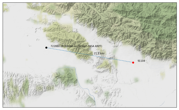
Charting Station mappings
Note
Requires matplotlib to be installed.
Within (for example) a jupyter notebook you can create plots like this:
>>> station = eeweather.ISDStation('722990')
>>> eeweather.plot_station_mapping(
...     lat, lng, station, distance_meters=21900, target='91104')
This will create a plot like the following:
Advanced database inspection
Using the CLI
If you prefer a GUI: SQLite Browser
The default database location is ~/.eeweather/cache.db.
How to log into the database:
$ eeweather inspect_db
SQLite version 3.19.3 2017-06-27 16:48:08
Enter ".help" for usage hints.
sqlite>
List all tables:
sqlite> .tables
Turn on headers for results:
sqlite> .headers on
Example queries
Get more information about a specific ISD station.
select
  *
from
  isd_station_metadata
where
  usaf_id = '722860'
Rebuilding the Database
The metadata database can be rebuilt from primary sources using the CLI.
Exercise some caution when running this command, as it will overwrite the existing db:
$ eeweather rebuild_db
To see all options, run:
$ eeweather rebuild_db --help
Usage: eeweather rebuild_db [OPTIONS]

Options:
  --zcta-geometry / --no-zcta-geometry
  --iecc-climate-zone-geometry / --no-iecc-climate-zone-geometry
  --iecc-moisture-regime-geometry / --no-iecc-moisture-regime-geometry
  --ba-climate-zone-geometry / --no-ba-climate-zone-geometry
  --ca-climate-zone-geometry / --no-ca-climate-zone-geometry
  --n-closest-stations INTEGER
  --help                          Show this message and exit.
API Docs
Ranking
-
eeweather.rank_stations(site_latitude, site_longitude, site_state=None, site_elevation=None, match_iecc_climate_zone=False, match_iecc_moisture_regime=False, match_ba_climate_zone=False, match_ca_climate_zone=False, match_state=False, minimum_quality=None, minimum_tmy3_class=None, max_distance_meters=None, max_difference_elevation_meters=None, is_tmy3=None, is_cz2010=None)[source]¶ Get a ranked, filtered set of candidate weather stations and metadata for a particular site.
Parameters: - site_latitude (float) – Latitude of target site for which to find candidate weather stations.
- site_longitude (float) – Longitude of target site for which to find candidate weather stations.
- site_state (str, 2 letter abbreviation) – US state of target site, used optionally to filter potential candidate
weather stations. Ignored unless
match_state=True. - site_elevation (float) – Elevation of target site in meters, used optionally to filter potential
candidate weather stations. Ignored unless
max_difference_elevation_metersis set. - match_iecc_climate_zone (bool) – If
True, filter candidate weather stations to those matching the IECC climate zone of the target site. - match_iecc_moisture_regime (bool) – If
True, filter candidate weather stations to those matching the IECC moisture regime of the target site. - match_ca_climate_zone (bool) – If
True, filter candidate weather stations to those matching the CA climate zone of the target site. - match_ba_climate_zone (bool) – If
True, filter candidate weather stations to those matching the Building America climate zone of the target site. - match_state (bool) – If
True, filter candidate weather stations to those matching the US state of the target site, as specified bysite_state=True. - minimum_quality (str,
'high','medium','low') – If given, filter candidate weather stations to those meeting or exceeding the given quality, as summarized by the frequency and availability of observations in the NOAA Integrated Surface Database. - minimum_tmy3_class (str,
'I','II','III') – If given, filter candidate weather stations to those meeting or exceeding the given class, as reported in the NREL TMY3 metadata. - max_distance_meters (float) – If given, filter candidate weather stations to those within the
max_distance_metersof the target site location. - max_difference_elevation_meters (float) – If given, filter candidate weather stations to those with elevations
within
max_difference_elevation_metersof the target site elevation. - is_tmy3 (bool) – If given, filter candidate weather stations to those for which TMY3 normal year temperature data is available.
- is_cz2010 (bool) – If given, filter candidate weather stations to those for which CZ2010 normal year temperature data is available.
Returns: ranked_filtered_candidates – Index is
usaf_id. Each row contains a potential weather station match and metadata. Contains the following columns:rank: Rank of weather station match for the target site.distance_meters: Distance from target site to weather station site.latitude: Latitude of weather station site.longitude: Longitude of weather station site.iecc_climate_zone: IECC Climate Zone ID (1-8)iecc_moisture_regime: IECC Moisture Regime ID (A-C)ba_climate_zone: Building America climate zone nameca_climate_zone: Califoria climate zone numberrough_quality: Approximate measure of frequency of ISD observations data at weather station.elevation: Elevation of weather station site, if available.state: US state of weather station site, if applicable.tmy3_class: Weather station class as reported by NREL TMY3, if availableis_tmy3: Weather station has associated TMY3 data.is_cz2010: Weather station has associated CZ2010 data.difference_elevation_meters: Absolute difference in meters between target site elevation and weather station elevation, if available.
Return type:
-
eeweather.combine_ranked_stations(rankings)[source]¶ Combine
pandas.DataFrames of candidate weather stations to form a hybrid ranking dataframe.Parameters: rankings (list of pandas.DataFrame) – Dataframes of ranked weather station candidates and metadata. All ranking dataframes should have the same columns and must be sorted by rank.Returns: ranked_filtered_candidates – Dataframe has a rank column and the same columns given in the source dataframes. Return type: pandas.DataFrame
-
eeweather.select_station(candidates, coverage_range=None, min_fraction_coverage=0.9, distance_warnings=(50000, 200000), rank=1, fetch_from_web=True)[source]¶ Select a station from a list of candidates that meets given data quality criteria.
Parameters: candidates ( pandas.DataFrame) – A dataframe of the form given byeeweather.rank_stationsoreeweather.combine_ranked_stations, specifically having at least an index withusaf_idvalues and the columndistance_meters.Returns: isd_station, warnings – A qualified weather station. Noneif no station meets criteria.Return type: tuple of ( eeweather.ISDStation, list of str)
ISDStation objects
-
class
eeweather.ISDStation(usaf_id, load_metadata=True)[source]¶ A representation of an Integrated Surface Database weather station.
Contains data about a particular ISD station, as well as methods to pull data for this station.
Parameters: -
wban_ids¶ list of WBAN IDs, or “99999” which have been used to identify the station.
Type: list of str
-
recent_wban_id = None WBAN ID most recently used to identify the station.
-
climate_zones = {} dict of all climate zones.
-
cached_gsod_daily_temp_data_is_expired(year)[source]¶ Return True if cache of resampled daily GSOD temperature data has expired or does not exist for the given year.
-
cached_isd_daily_temp_data_is_expired(year)[source]¶ Return True if cache of resampled daily ISD temperature data has expired or does not exist for the given year.
-
cached_isd_hourly_temp_data_is_expired(year)[source]¶ Return True if cache of resampled hourly ISD temperature data has expired or does not exist for the given year.
-
deserialize_cz2010_hourly_temp_data(data)[source]¶ Deserialize JSON representation of hourly CZ2010 into pandas time series.
-
deserialize_gsod_daily_temp_data(data)[source]¶ Deserialize JSON representation of resampled daily GSOD into pandas time series.
-
deserialize_isd_daily_temp_data(data)[source]¶ Deserialize JSON representation of resampled daily ISD into pandas time series.
-
deserialize_isd_hourly_temp_data(data)[source]¶ Deserialize JSON representation of resampled hourly ISD into pandas time series.
-
deserialize_tmy3_hourly_temp_data(data)[source]¶ Deserialize JSON representation of hourly TMY3 into pandas time series.
-
destroy_cached_cz2010_hourly_temp_data()[source]¶ Remove cached hourly CZ2010 temperature data to cache.
-
destroy_cached_gsod_daily_temp_data(year)[source]¶ Remove cached resampled daily GSOD temperature data to cache for given year.
-
destroy_cached_isd_daily_temp_data(year)[source]¶ Remove cached resampled daily ISD temperature data to cache for given year.
-
destroy_cached_isd_hourly_temp_data(year)[source]¶ Remove cached resampled hourly ISD temperature data to cache for given year.
-
destroy_cached_tmy3_hourly_temp_data()[source]¶ Remove cached hourly TMY3 temperature data to cache.
-
fetch_cz2010_hourly_temp_data()[source]¶ Pull hourly CZ2010 temperature hourly time series from URL.
-
fetch_gsod_daily_temp_data(year)[source]¶ Pull raw GSOD temperature data for the given year directly from FTP and resample to daily time series.
-
fetch_isd_daily_temp_data(year)[source]¶ Pull raw ISD temperature data for the given year directly from FTP and resample to daily time series.
-
fetch_isd_hourly_temp_data(year)[source]¶ Pull raw ISD temperature data for the given year directly from FTP and resample to hourly time series.
-
fetch_tmy3_hourly_temp_data()[source]¶ Pull hourly TMY3 temperature hourly time series directly from NREL.
-
get_cz2010_hourly_temp_data_cache_key()[source]¶ Get key used to cache CZ2010 weather-normalized temperature data.
-
get_gsod_daily_temp_data_cache_key(year)[source]¶ Get key used to cache resampled daily GSOD temperature data for the given year.
-
get_isd_daily_temp_data_cache_key(year)[source]¶ Get key used to cache resampled daily ISD temperature data for the given year.
-
get_isd_hourly_temp_data_cache_key(year)[source]¶ Get key used to cache resampled hourly ISD temperature data for the given year.
-
get_tmy3_hourly_temp_data_cache_key()[source]¶ Get key used to cache TMY3 weather-normalized temperature data.
-
load_cached_cz2010_hourly_temp_data()[source]¶ Load all cached hourly TMY3 temperature data (the year is set to 1900)
-
load_cached_tmy3_hourly_temp_data()[source]¶ Load all cached hourly TMY3 temperature data (the year is set to 1900)
-
load_cz2010_hourly_temp_data(start, end, read_from_cache=True, write_to_cache=True, fetch_from_web=True)[source]¶ Load hourly CZ2010 temperature data from start date to end date (inclusive).
This is the primary convenience method for loading hourly CZ2010 temperature data.
Parameters: - start (datetime.datetime) – The earliest date from which to load data.
- end (datetime.datetime) – The latest date until which to load data.
- read_from_cache (bool) – Whether or not to load data from cache.
- write_to_cache (bool) – Whether or not to write newly loaded data to cache.
- fetch_from_web (bool) – Whether or not to fetch data from ftp.
-
load_cz2010_hourly_temp_data_cached_proxy(fetch_from_web=True)[source]¶ Load hourly CZ2010 temperature data from cache, or if it is expired or hadn’t been cached, fetch from URL.
-
load_gsod_daily_temp_data(start, end, read_from_cache=True, write_to_cache=True, fetch_from_web=True)[source]¶ Load resampled daily GSOD temperature data from start date to end date (inclusive).
This is the primary convenience method for loading resampled daily GSOD temperature data.
Parameters: - start (datetime.datetime) – The earliest date from which to load data.
- end (datetime.datetime) – The latest date until which to load data.
- read_from_cache (bool) – Whether or not to load data from cache.
- write_to_cache (bool) – Whether or not to write newly loaded data to cache.
- fetch_from_web (bool) – Whether or not to fetch data from ftp.
-
load_gsod_daily_temp_data_cached_proxy(year, fetch_from_web=True)[source]¶ Load resampled daily GSOD temperature data from cache, or if it is expired or hadn’t been cached, fetch from FTP for given year.
-
load_isd_daily_temp_data(start, end, read_from_cache=True, write_to_cache=True, fetch_from_web=True)[source]¶ Load resampled daily ISD temperature data from start date to end date (inclusive).
This is the primary convenience method for loading resampled daily ISD temperature data.
Parameters: - start (datetime.datetime) – The earliest date from which to load data.
- end (datetime.datetime) – The latest date until which to load data.
- read_from_cache (bool) – Whether or not to load data from cache.
- fetch_from_web (bool) – Whether or not to fetch data from ftp.
- write_to_cache (bool) – Whether or not to write newly loaded data to cache.
-
load_isd_daily_temp_data_cached_proxy(year, fetch_from_web=True)[source]¶ Load resampled daily ISD temperature data from cache, or if it is expired or hadn’t been cached, fetch from FTP for given year.
-
load_isd_hourly_temp_data(start, end, read_from_cache=True, write_to_cache=True, fetch_from_web=True, error_on_missing_years=True)[source]¶ Load resampled hourly ISD temperature data from start date to end date (inclusive).
This is the primary convenience method for loading resampled hourly ISD temperature data.
Parameters: - start (datetime.datetime) – The earliest date from which to load data.
- end (datetime.datetime) – The latest date until which to load data.
- read_from_cache (bool) – Whether or not to load data from cache.
- fetch_from_web (bool) – Whether or not to fetch data from ftp.
- write_to_cache (bool) – Whether or not to write newly loaded data to cache.
-
load_isd_hourly_temp_data_cached_proxy(year, fetch_from_web=True)[source]¶ Load resampled hourly ISD temperature data from cache, or if it is expired or hadn’t been cached, fetch from FTP for given year.
-
load_tmy3_hourly_temp_data(start, end, read_from_cache=True, write_to_cache=True, fetch_from_web=True)[source]¶ Load hourly TMY3 temperature data from start date to end date (inclusive).
This is the primary convenience method for loading hourly TMY3 temperature data.
Parameters: - start (datetime.datetime) – The earliest date from which to load data.
- end (datetime.datetime) – The latest date until which to load data.
- read_from_cache (bool) – Whether or not to load data from cache.
- write_to_cache (bool) – Whether or not to write newly loaded data to cache.
- fetch_from_web (bool) – Whether or not to fetch data from ftp.
-
load_tmy3_hourly_temp_data_cached_proxy(fetch_from_web=True)[source]¶ Load hourly TMY3 temperature data from cache, or if it is expired or hadn’t been cached, fetch from NREL.
-
read_cz2010_hourly_temp_data_from_cache()[source]¶ Get cached version of hourly TMY3 temperature data.
-
read_gsod_daily_temp_data_from_cache(year)[source]¶ Get cached version of resampled daily GSOD temperature data for given year.
-
read_isd_daily_temp_data_from_cache(year)[source]¶ Get cached version of resampled daily ISD temperature data for given year.
-
read_isd_hourly_temp_data_from_cache(year)[source]¶ Get cached version of resampled hourly ISD temperature data for given year.
-
read_tmy3_hourly_temp_data_from_cache()[source]¶ Get cached version of hourly TMY3 temperature data.
-
serialize_cz2010_hourly_temp_data(ts)[source]¶ Serialize hourly CZ2010 pandas time series as JSON for caching.
-
serialize_gsod_daily_temp_data(ts)[source]¶ Serialize resampled daily GSOD pandas time series as JSON for caching.
-
serialize_isd_daily_temp_data(ts)[source]¶ Serialize resampled daily ISD pandas time series as JSON for caching.
-
serialize_isd_hourly_temp_data(ts)[source]¶ Serialize resampled hourly ISD pandas time series as JSON for caching.
-
serialize_tmy3_hourly_temp_data(ts)[source]¶ Serialize hourly TMY3 pandas time series as JSON for caching.
-
validate_gsod_daily_temp_data_cache(year)[source]¶ Delete cached resampled daily GSOD temperature data if it has expired for the given year.
-
validate_isd_daily_temp_data_cache(year)[source]¶ Delete cached resampled daily ISD temperature data if it has expired for the given year.
-
validate_isd_hourly_temp_data_cache(year)[source]¶ Delete cached resampled hourly ISD temperature data if it has expired for the given year.
-
write_cz2010_hourly_temp_data_to_cache(ts)[source]¶ Write hourly CZ2010 temperature data to cache for given year.
-
write_gsod_daily_temp_data_to_cache(year, ts)[source]¶ Write resampled daily GSOD temperature data to cache for given year.
-
write_isd_daily_temp_data_to_cache(year, ts)[source]¶ Write resampled daily ISD temperature data to cache for given year.
-
Summaries
-
eeweather.summaries.get_zcta_ids(state=None)[source]¶ Get ids of all supported ZCTAs, optionally by state.
Parameters: state (str, optional) – Select zipcodes only from this state or territory, given as 2-letter abbreviation (e.g., 'CA','PR').Returns: results – List of all supported selected ZCTA IDs. Return type: list of str
-
eeweather.summaries.get_isd_station_usaf_ids(state=None)[source]¶ Get USAF IDs of all supported ISD stations, optionally by state.
Parameters: state (str, optional) – Select ISD station USAF IDs only from this state or territory, given as 2-letter abbreviation (e.g., 'CA','PR').Returns: results – List of all supported selected ISD station USAF IDs. Return type: list of str
Geography
-
eeweather.geo.get_lat_long_climate_zones(latitude, longitude)[source]¶ Get climate zones that contain lat/long coordinates.
Parameters: Returns: climate_zones – Region ids for each climate zone type.
Return type: dict of str
-
eeweather.geo.get_zcta_metadata(zcta)[source]¶ Get metadata about a ZIP Code Tabulation Area (ZCTA).
Parameters: zcta (str) – ID of ZIP Code Tabulation Area Returns: metadata – Dict of data about the ZCTA, including lat/long coordinates. Return type: dict
-
eeweather.geo.zcta_to_lat_long(zcta)[source]¶ Get location of ZCTA centroid
Retrieves latitude and longitude of centroid of ZCTA to use for matching with weather station.
Parameters: zcta (str) – ID of the target ZCTA. Returns: - latitude (float) – Latitude of centroid of ZCTA.
- longitude (float) – Target Longitude of centroid of ZCTA.
Database
-
eeweather.database.build_metadata_db(zcta_geometry=False, iecc_climate_zone_geometry=True, iecc_moisture_regime_geometry=True, ba_climate_zone_geometry=True, ca_climate_zone_geometry=True)[source]¶ Build database of metadata from primary sources.
Downloads primary sources, clears existing DB, and rebuilds from scratch.
Parameters: - zcta_geometry (bool, optional) – Whether or not to include ZCTA geometry in database.
- iecc_climate_zone_geometry (bool, optional) – Whether or not to include IECC Climate Zone geometry in database.
- iecc_moisture_regime_geometry (bool, optional) – Whether or not to include IECC Moisture Regime geometry in database.
- ba_climate_zone_geometry (bool, optional) – Whether or not to include Building America Climate Zone geometry in database.
- ca_climate_zone_geometry (bool, optional) – Whether or not to include California Building Climate Zone Area geometry in database.
Exceptions
-
exception
eeweather.ISDDataNotAvailableError(usaf_id, year)[source]¶ Raised when ISD data is not available for a particular station and year.
